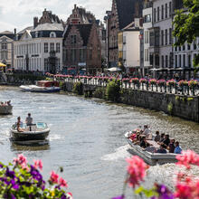
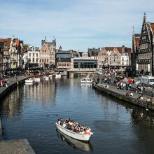
©Stad Gent - Dienst Toerisme
This boat trip has been made possible with the support of the Interreg programme “France-Wallonie-Vlaanderen – Golden Leie-Lys”.

The green St.-Agnetebrug bridge is also known as the Entrepotbrug bridge, which is a reference to the warehouse in the neighbourhood. This green drawbridge is named after the convent that once stood at Lindelei and was mentioned for the first time in documents from 1462 and demolished in 1826 to make way for the Nijverheidsschool industrial school.
The Sint-Agneta lock basin was built when the Coupure canal was connected to the Lys river in the mid-18th century. The lock gates, whose slots are still visible in the masonry, regulated the water level in the city centre.
In the beginning of the 19th century, the lock gates were left open, because the canal's water level could no longer be raised above that of the lock basin. The bargemen were satisfied with this decision. The lock gates disappeared in 1823.
Start at the jetty at Coupure Links 9a and pass under the green Sint-Agnetebrug bridge. Turn right immediately afterwards and pass under another bridge. A little further, you will pass by the Bijloke site on your right.
The site got its name from the Bijlokemeersen meadows, which were donated by Joan, Countess of Flanders, in the 13th century for the establishment of a hospital. The Bijloke hospital was built first, followed by an abbey.
Eventually, the complex consisted of a hospital, an abbey and utility buildings from three periods: the Middle Ages, the 17th and the 19th century. Nowadays, the Bijloke site is a cultural centre that includes the Ghent City Museum (STAM), music centre De Bijloke, the Royal Academy of Fine Arts and the Hogeschool Gent music school.
First pass under Godshuizenlaan, and you will see the Koning Albertbrug bridge, where you can spot Residence Belvédère.

Residence Belvédère adds a playful 1950s note to the area with its Y-shaped floor plan, the canopy above the entrance and the large overhanging cornice, contrasting with the other, more austere blocks of flats around the Watersportbaan sports facilities. The youngest and westernmost block of flats has been given a major make-over. Architectenbureau Van Derbeken was responsible for the renovation project after being commissioned by ABC Maatschappij voor Sociale Woningbouw.
To add an extra touch to the building, the mechanical penthouse on the 19th floor is lit with green light, which makes the building a recognisable landmark, even at night.
Continue along the Henleykaai quay, where the Millionaires' Quarter is located.
Ghent's population grew exponentially in the 19th century due to strong industrialisation. The increasingly crowded city expanded northwards around the harbour, while the wealthy bourgeoisie moved to the southern outskirts of the city and built rather elitist residential neighbourhoods in rural surroundings. The Millionaires’ Quarter was built in the interwar period on the 1913 World’s Fair grounds.
The earlier plan to build barracks, which got stuck in its design phase due to the First World War, is remembered in the military or patriotic character of the current street names: Krijgslaan, Onafhankelijkheidslaan, Vaderlandstraat, Congreslaan, Woeringenstraat, Jemappesstraat and Fleurrusstraat.
Turn around and head back to the city centre. Once you have returned, navigate past the starting point until you reach the Old Law Courts.
The courthouse was built between 1836 and 1846 according to the design of city architect Louis Roelandt (1786-1864) in neoclassical style with Florentine Renaissance elements, after a Recollect friary had been demolished at the end of the 18th century and the space that became available had been used for several decades to hold a merchant market twice a week.
The basement and ground floor, which included warehouses and a trade fair venue, were intended for the merchants. The upper floors were intended for legal services. As these services eventually ran out of space, the trade fair venue was moved to Kouter square in 1900.
The entire interior was destroyed in a huge fire in 1926. Only the outer walls remained standing. In 1930, the court was rebuilt under the supervision of architect M. De Vaere. The interior was completely renovated. The number of usable rooms and halls was increased from 58 to 100.
Only the Court of Appeal remains in this building, after most of the departments moved to the new courthouse in the Rabot district in 2007.
Turn right into the Ketelvaart canal. On your left, you will immediately see the rear of the Opera and the Handelsbeurs concert hall.

The Opera, originally called "Grand Théâtre", was built for opera performances between 1837 and 1840 in neo-classical style by Ghent city architect Louis Roelandt on the site of the demolished Sint-Sebastiaanschouwburg theatre, which was the theatre of the archers' guild in the 18th century. Later on, it became the Royal Opera of Ghent. The Opera has been modified, redecorated and altered a few times in its more than 175 years of existence, but nevertheless it is a fairly well-preserved example of a typical "French" theatre from the first half of the 19th century.
Nowadays, Handelsbeurs is a modern medium-sized concert hall, located in the monumental former trade fair building on Kouter square. The building was thoroughly renovated in 2002 after years of vacancy. The city of Ghent bought the ballroom L'Union in 1899. It is located next to the guardhouse (1739), which was already city property. Architect Charles van Rysselberghe was commissioned to combine both buildings into one, in which Ghent’s trade fair would take place. The building was renovated again in 1906. That same year, a hall was also built under Charles’ van Rysselberghe’s supervision in the guardhouse: an exhibition room with paintings by Armand Heins. The former party hall L'Union now serves as the current concert hall’s foyer, while the exhibition room in the former guardhouse has been converted into a modern concert hall with a flexible layout.
After passing under the Walpoortbrug bridge at the end, you will see the impressive De Krook library on your right.
The neighbourhood has a long history and was an attractive harbour thanks to its location. It was named De Waalse Krook in 1943. 'Krook' is an old word for wrinkle or fold, and refers to the bend of the river Scheldt and the place where ships unloaded coal from Wallonia in the 18th and 19th centuries.
The developers announced in May 2013 that the site would no longer be called 'Waalse Krook', but simply ‘De Krook’, which is also the name of the new city library that opened its doors in 2017.
Follow the river to the right. Beyond the next bridge, you will see arts centre Vooruit.

Based on a design by Ferdinand Dierkens, construction started in 1911, and in 1913, the building opened its doors as the festive and arts centre of the Ghent socialist workers' movement, with a party hall (ballroom), cinema, theatre company, etc. Workers could eat, drink and enjoy culture at very affordable prices in ‘arts temple Vooruit’. Vooruit as a socialist festive and arts centre was part of the compartmentalised Flemish society before World War II. After the war, the building deteriorated until 1982, when it was converted into its present form as an arts centre and in 1983, it was listed as a monument. It was awarded the Flemish Monument Prize in 2000 after thorough restoration work.
Continue straight ahead and discover the beautiful St Peter's Abbey on the right.
St Peter's Abbey is a former Benedictine abbey and is located on the 28 metre high Blandijnberg hill (the highest point of the city), along the old course of the Scheldt river, which is also called Muinkschelde (Monk Scheldt). The abbey was originally called Blandinium, which is a reference to the Gallo-Roman who is said to have been in possession of this land in the 7th century. It was besieged several times because of its wealth. In the winter of 879-880, it was sacked by the Vikings and in the 16th century it suffered badly during the wars of religion.
The last monks left the abbey at the end of the 18th century. Afterwards, the buildings were used as barracks and served as a prison until 1948. Now, they serve as exhibition spaces, the World of Kina, and visitors are given the opportunity to visit the abbey with Alison, a virtual monk.
On the slope towards the river Scheldt, the monks grew grapes to make white wine. Napoleon Bonaparte put an end to this tradition. Grapevines have been growing again on the southern slope since 2008.
A little beyond the Kinepolis cinema, turn around at the little tower called “Peperbus” and right before the Kantienberg bridge, and return to De Krook. In the bend at De Krook, look to your right for the entrance of the tunnel that will take you under F. Laurentplein square.

F. Laurentplein square was constructed in 1884, when this part of the river Nederschelde was covered to reduce pollution and odour nuisance in the city. Small boats can navigate underneath the square, and encounter the Wijdenaardbrug bridge a little further. The section between this bridge and the Nieuwbrug bridge was filled in around 1960, but opened up again in 2018.
When you can’t go any further at the Scaldissluis lock, turn around. You’re now navigating along De Reep again.
The river Nederschelde, also known as De Reep, is the part of the river Scheldt that flows through Ghent's city centre. The part of the river that flows from its source to Ghent is known as the Bovenschelde.
Shipping disappeared from Ghent when the Ringvaart canal was dug, and this part of the Nederschelde was filled in to make room for a car park and to avoid odour nuisance. The confluence of the Scheldt and Lys rivers, which was originally situated here, was moved to the Ringvaart canal.
At the end of the 20th century, the filling in of waterways was considered to be a mistake. Odour nuisance was no longer an issue and the natural confluence of the Lys and Scheldt rivers needed to be restored. That is why, in 2002, the waterway at De Reep was reopened, 3 bridges and the Scaldissluis lock were built at Oude Beestenmarkt and the Portus Ganda area was redeveloped.
The confluence of the Scheldt and Lys rivers was restored on 24 September 2018, when the last bit of soil between the two rivers was dug out at De Reep.
Back at the Old Law Courts, you can see the sculptures ‘Scheldt’ and ‘Lys’ adorning the buildings in front and behind you.

At the end of the last century, Philippe Timmermans made one of Ghent’s most famous sculptures: the life-size diver located at Lindelei. When enthusiastic neighbours ensured that its female counterpart, the ‘Diving Lady’ by London artist Ronald Cameron, was placed on the home of architect Stoop 10 years later, the urban legend about the confluence of the Scheldt and Lys rivers was born.
This story is now told to every tourist enjoying a boat trip in Ghent.
Navigate to the right and continue your trip. Immediately past the Predikherenbrug bridge, you will notice Het Pand on the left.
Het Pand is a former Dominican friary. Ghent University has owned the building since 1963 and has used it to accommodate a cultural centre and several scientific museums. The entire building is listed as a monument.
The 13th-century building was originally used as a hospital, but soon became too small and was donated to the Dominican Order. Two churches were built, one of which has been preserved: St Michael’s Church.
Throughout its history, Het Pand was destroyed and looted several times, until the last Dominicans left the premises during the French Revolution. The building subsequently became private property and was mismanaged for commercial purposes. Even though the building became increasingly dilapidated and was declared uninhabitable, it was listed as a monument.
On 25 January 1963, Het Pand was sold to Ghent University, which had the building restored between 1971 and 1991 and now uses it as a congress and cultural centre. It also accommodates a high-class restaurant and lounge bar called ‘Club Het Pand’.
Continue straight ahead. After you pass underneath St Michael’s Bridge, you will see the beautiful Guild Halls on the left and right side on Graslei and Korenlei.

The Guild Halls were buildings historically used as offices by the heads of the guilds and where their members gathered. Meetings and joint meals were held, during which the members drank from the guild cup.
Guild halls were mainly for the larger guilds. The oldest ones date back to the Middle Ages. Some of the most important city monuments are the prominent buildings constructed by the biggest or richest guilds at prominent locations of the larger towns.
At the end, pass under the Grasbrug bridge and keep straight ahead. On your left, the Lieve canal flows into the river Lys right before the Old Fish Market. Across from the Old Fish Market, you can find the Great Butchers' Hall.
Ghent's Great Butchers' Hall is a former covered market and guild hall. In the Middle Ages, the sale of meat was centralised in meat markets or butchers’ halls so that it could be controlled. It was prohibited to sell meat at home. Every medieval town had one or more butchers’ halls. The Great Butchers’ Hall, which was centrally located, was mentioned for the first time in documents from 1251.
The original butchers’ hall was very different from the current building. It was a wooden building that was a lot smaller and didn't reach the Vleeshuisbrug bridge. Over the years, alterations and additions were carried out.
The Great Butchers’ Hall was repurposed many times, and was used as a fruit and vegetable market, Post and Telegraph Office, car park and fish market. Nowadays, the building is used as a promotional centre for East Flemish regional products.
Behind the Old Fish Market, you can find the Castle of the Counts, and the Patershol neighbourhood on the left.

As the only remaining medieval castle in Flanders, the Castle of the Counts is a special attraction. The gate house, the rampart, the keep, the count’s residence and the stables are open to the public.
The Counts of Flanders opted for a high sand dune with swampy banks next to the river Lys for the construction of a fortress.
Count Baldwin I (837-879) presumably had the first fortress built as a defence against the Vikings’ incursions. Over the centuries, the castle was drastically altered and rebuilt several times.
People came to appreciate the Castle of the Counts in the late 19th century. The government and the city bought the complex back from private ownership in several stages. Impressive remains of the medieval castle were uncovered, and the first major restoration started in 1894. The castle is still being restored today. Two thirds of the castle have once again been surrounded by water since June 2016.
This picturesque neighbourhood is called Patershol, and is now home to many small cafés and restaurants.
Monks settled here at the end of the 13th century. Towards the end of the 15th century, mainly lawyers and magistrates settled in this neighbourhood because the Council of Flanders was accommodated in the nearby Castle of the Counts. Tradespeople and craftsmen joined them later on. While it was originally a wealthy neighbourhood, it transformed into a working-class neighbourhood during the industrialisation at the beginning of the 19th century. Many of the bigger buildings were torn down or divided into smaller workers’ flats.
The Patershol area and its narrow streets slowly turned into an impoverished neighbourhood or ghetto when the industry and its employees moved to the suburbs at the end of the 19th century. Nevertheless, from the end of the 19th century onwards, many generations of artists found their home in the neighbourhood. Private investors and the city council started restoring and renovating the Patershol area in the early 1980s, which meant a touristic upgrade of the neighbourhood.
You pass the House of Alijn on the left, and a little further, right in front of the next bridge, the Mad Meg canon is located on the right. Beyond, you can find Vrijdagmarkt square.
The origins of the House of Alijn go back to 1926, when the Royal East Flemish Folklore Association was founded. The aim of the association was to promote the study of popular traditions. This was realised by publishing the folkloric magazine Oost-Vlaamse Zanten from 1927 onwards, and by setting up a folkloric library. The association’s collection, which was initially housed in the library, grew so strongly in the following years that a new home was required. The Folklore Museum was founded in 1932. Ten years after it was founded, the museum housed the puppet theatre Het Spelleke van Folklore, previously known as Spelleke van de Muide, which has remained there to this day. In 1962, the Folklore Museum moved from Lange Steenstraat to the Kinderen Alijn hospital on Kraanlei and was renamed Museum of Folklore. In 2000, the museum underwent its most drastic facelift to date; the Museum of Folklore became the House of Alijn. The name change heralded a new policy and reorientation. “The House of Alijn wants to be a house with an open door to the world, where heritage is dealt with in a creative and quality-conserving way and where the relationship with the neighbourhood and the city is restored.”[4] The House of Alijn is not the only folklore museum to change course. Museums in Rotterdam and Leiden also opted for a change of course around the same period.
‘Mad Meg’ is a monumental, iron cannon from 1431. It also used to be called "Groten Rooden Duyvele” (“Big Red Devil”) because of its original red colour. It was transported from Oudenaarde to Ghent with other weaponry in 1578 to be used in the fight against the Spanish. It is unclear whether the cannon was stolen or gifted.
Vrijdagmarkt square is one of the oldest squares in the city. It covers an area of about one hectare and has played an important role in the city's history. It's where the Joyous Entries of the Counts of Flanders used to take place. It was the Ghentians’ forum where jousts were organised. The square was also used for executions and settlements. The weekly market has been held on the square every Friday morning since 1199. Public life mostly took place here, both politically and socially.
Continue a little further and pass the old factory buildings, now Ghent River Hotel, and make a final turn at a lock at Portus Ganda, where you cannot go further. Navigate through the historical centre again, and cast a last glance at the impressive three towers near St Michael's Bridge and the Old Post Office.

The monumental St Michael's Bridge was built in the 1905-1909 period, after the construction of the post office. Both St Michael's Bridge and the Post Office were designed by architect Louis Cloquet. Previously, there was a flat swing bridge. From the bridge, you can see Graslei and Korenlei to the north, and the Castle of the Counts in the distance. In an easterly direction, the bridge provides the typical view of Ghent's three towers: St Nicholas' Church, the Ghent Belfry and St Bavo's Cathedral. An ideal crowd pleaser for the 1913 World’s Fair.
Medieval Ghent’s skyline was, and still is, determined by three towers that were built in a row in the middle of the city centre. From Graslei, the first tower you see is St Nicholas' Church, which was constructed on the old foundations of previous thirteenth-century buildings and is a prime example of the Scheldt Gothic style.
The second tower is the Belfry. When the citizenry in medieval cities became richer and more powerful, they wanted to show their wealth by building large towers like this one. The tower also served as a guard tower and housed a bell which sounded the alarm and marked the beginning and the end of each working day (as people did not have watches or clocks). In times of emergency and disaster, the town’s bells were rung to warn all citizens.
The third tower is St Bavo's Cathedral. Aside from the fact that it is a beautiful church, its fame is mainly due to the presence of the Ghent Altarpiece by Van Eyck.
We are approaching the end of the route. Continue for a little bit and turn left at the Coupure canal. Here you will find your jetty.